

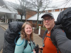
After nearly 8 years of dreaming we are finally hiking the AT. Today was a little more grueling for us than it should have been for a number of reasons, but I’ll get into that soon enough.

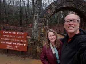
I’m going to present our mileage’s in a little different manner than I have in the past. The first number will be the actual trail miles followed by the total number of miles we had to hike to accomplish the official miles. As you might notice, we only hiked 2/10 ths of a mile on the AT today, but it took us almost 9 miles to do it. Most people will probably assume that I just put Pam (henceforth known as Bunny Tracks or Bunny T) out front to lead the way. Even though these numbers would reflect such a happening, that wasn’t the case today. We had to hike up the approach trail from Amicalola Falls State Park in Georgia before we could get to the trail.
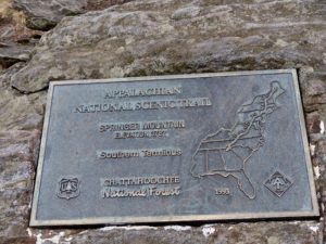
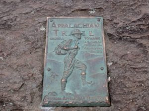
The Appalachian Trail is officially 2,190.3 miles this year, but there’s more to it than that because you can’t drive to either Trail Head. In Georgia, there is an 8.8 mile approach trail which is regarded as the semi-official start, but not everyone gets on the trail this way or hikes the entire approach trail as is the case with us—we skipped the first mile of the trail which is the climb up Amicalola Falls). I wasn’t thrilled about skipping it, but we stayed at the Lodge last night so we were already above the falls so it just didn’t make sense to back track to the bottom. Now that we are on the AT, we will white blaze the entire trail (unless we run into forest fires or another government shutdown).

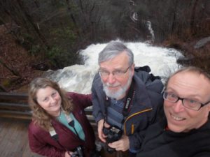
We took the “6 state challenge” to get down here yesterday. That is, we rode with George through Missouri, Illinois, Kentucky, Tennessee, Alabama, and Georgia. I got my first blister of the trip on that drive down. I was riding shotgun and George is a surprisingly aggressive driver who places a lot of faith in his brakes. I spent a lot of the time trying to slam on the brakes on my side and developed a blister on the side of my big toe, but I’m a former cross-fitter so I know how to deal with blisters—ignore them.
Back to the AT total “official” length. It is believed that the average hiker will take right around 5 million steps to complete the trail. As can be surmised from our progress today, we only have 4,999,500 steps to go until we hit Katahdin—slice of pie (or piece of cake—I get my idioms mixed up).
Why was today so hard for us? Well, it’s February 12 and we are starting to hike. We have to assume that we are going to hit some pretty cold weather so I’m carrying about an extra 10 pounds of winter gear in my packweight’s 45 pounds. Bunny is carrying at least an extra 5 pounds of crap (not necessarily winter gear, but more vitamins, clothes, tea, personal crap, etc.) in her 35 pounds of packweight. We will get rid of this extra gear in a few weeks when Pam and Joyce join us as we hike through the Smoky Mountain National Park.
However, we have some additional weight that we are carrying that we didn’t have on the GR10 and the TMB last year. Namely, bellies from sightseeing, drinking, great home cooking, and, in my case, M&M’s reasonably priced right next to the dog food. I have put on nearly all the weight I lost last year—about 40 pounds. Bunny is carrying an extra 30. (We had a lot of fun trying the European food and beer.)

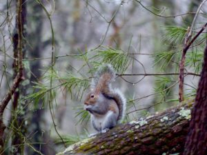
Although today was a beautiful day in the mid 60s with occasional blue skies, we aren’t going to stay that lucky. The 10 day forecast for our area only calls for 8 days of rain. As I’m writing this, the rain is gently beating down on the shelter metal roof and almost drowns out the sound of the mice scurrying around. Yes, Pam and Joyce, expect mice. They are the cutest little things. They haven’t gotten brave enough to get closer than a foot to us, but we are still awake. I’m sure they will be willing to cuddle in a few hours.

We didn’t get off quite as early as we were hoping this morning—this is a paragraph dedicated to our good friend Pete up north of the border (the one that hasn’t been designated as needing a wall, YET). George was supposed to wake up and shower to be ready to eat at 7a then we were going to shower after breakfast and head out by 8:30. George overslept and convinced us that it was very foggy out. He skipped breakfast and took off at 7:30. We decided to sleep a few more minutes. Yadda yadda yadda, we hit the trail at 10a (but to our credit, that’s Eastern Time so we really set off at 9–a mere questionably justifiable 30 minutes late).
We didn’t run into any fellow thru hikers at all today, but we did notice two signed in on the register atop of Springer Mountain. We fully expected to be sharing a shelter tonight, but have it all to ourselves (if you ignore the mice who were already here). We only ran into 2 people all day and they were just exercising their dogs.
We did run across a lot of gear on the side of the trail and in shelters we passed. In one location, we came across what appeared to be an abandoned campsite with sleeping bag, tent, and food all abandoned. I have heard of people deciding this trail is too tough and give up right away—I hope that was the case with this site. Hopefully, they were just having a “Brad moment” and threw all their gear off the trail and said they were “getting out of this chicken-shit outfit once and for all” and that they weren’t abducted by aliens. Although I would love to be an ambassador to another alien race, I’m not up for the associated anal probes that go with the job description.
EFG